Tuesday, May 30, 2006

And Canada's like, "What's going on eh?"

Well, since we finished up at Antietam, we've been busy travelling. For our last week before returning the mighty Kia Rio back to New York, we decided to spend four days driving up to Niagara Falls, complete a circle round Lake Ontario before returning to the US and to Gettysburg, where we'll spend three days to finish up.

It's been good. Driving first through backwoods Pennsylvania and upstate New York has given us a chance to experience some of the American countryside, and by god, it is magnificent. Massive hills and valley, covered in greenery. Rivers and creeks everywhere. Excellent quality highways to drive on (well, until you reach the Canadian border - more on that later.)

Driving in America is an interesting experience. Particularly when the old man is at the helm. For starters, he and I agree that it's a sensible practice to do the speed limit. There are plenty of super troopers infesting the road after all, and neither he or I want to be pulled over and be told to hand over our license and registration right meow, or be called chicken fuckers. So, we sit on 65 mph. Unlike everyone else on the highway. This results in the occasional case of tailgating. Which aggravates the old man more than anything else about highway driving. In fact, if we're on a normal road, he'd prefer to pull over and let them past rather than endure it. Of course, you can't do this on a Federal Interstate, so he just sits and grouses about it.

Which is amusing.

But the roads themselves make up for these minor issues. For those of you in Australia, picture the road from Ferny Grove to Samford. In America, that road is a dual carriageway, complete with on and off ramps. Every road between a town is decked out like the Gateway Motorway. It's fantastic.

Canada is more like Australia - the freeway here resembles the surface of the moon, such is the preponderance of craters. Road edges are about as crooked as Meakin's sense of ethics and morality. The drivers all think they're Michael Schumacher behind some Chrysler piece of shit, and hence we spent the trip from Niagara Falls to where we stopped, some fifty kilometres from Toronto trying to avoid shiny, guard-rail induced death.

Well, there's not really much to detail - I mean, we drove all day, we stopped the night, we drove some more, we saw a huge waterfall, we drove some more, we stopped and I started typing this. So I'll just let the pictures do the talking.

Without further ado....
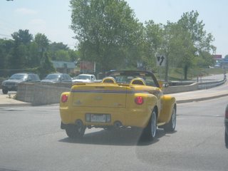

I don't know what the hell this is or was, but it's made by Chevy, has an SS badge and looked pretty cool, so I got a photo of it. This however, isn't the most ostentatious car we've seen so far. Stay tuned.


Believe it or not, that overbridge is just for some crappy little inter-county road. In Australia, they'd make you slog down into the valley and deal with a roundabout. Scrooges!


It's amazing what you can find just lying about on the side of the road. Seriously. This is apparently an M-60 Tank.


The business end.


Segregation is still alive and well, and living on Interstate 99. They probably want to frisk them for hubcaps.


I think when he parks this car, his tyres are in two separate counties. Wasn't that fast though - he was overtaken about 10 seconds later by an old man driving a Kia Rio, so yeah.


I think this sign is intended to warn us that we're passing through Michael Moore territory. Or that we're on a single lane road with blind corners that might have some nonce on a motorbike come blasting out of his driveway into one and almost collect us if it wasn't for violent evasive action on our part that almost saw us hit his dumb arse anyway.

Probably the latter.


Yeah, this sign doesn't work. Well, it does, but not when the old man is involved. Considering he's looking in the rear mirror and counting two seconds to see if the car behind him is too close. Woe betide the driver who gets within our back bumper before the old man has counted "one thousand and one, one thousand and tw-HE'S TOO DAMN CLOSE!"
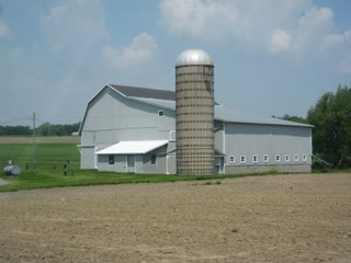

A fairly standard barn here in the states, complete with phallic grain silo.


A reasonably picturesque part of upstate New York.
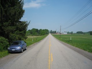

The mighty Kia, parked alongside a rural backdrop.


A typical American village. Seriously, communities like this are everywhere. It's not like Australia, where you could drive for an hour in the outback and not see a house, or another car. The whole country is settled. It's a completely different place.

You might have noticed I had a fair bit of time to photograph stuff both from inside and outside of the car whilst driving through these rural areas. How is this possible you ask? Easy.


Get stuck behind one of these bastards.

Ok, well now for the main event - Niagara Falls. It's huge, it's phenomenal, and it's coming right up!

After this pizza break. Here you go Laurie. As promised.


Right, now that's been sorted...


This is American Falls. Niagara Falls is essentially composed of three different waterfalls. Horseshoe Falls, which is hidden in the distance behind the huge cloud of mist and waterspray, is the largest. 90% of the water that passes through Niagara Falls goes over Horseshoe Falls. The remaining 10% goes over American Falls, which you can see front and center here, as well as Bridal Veil falls, which is a tiny waterfall in between the two giants.


This shows American Falls, and Bridal Veil falls, which is just to the right of American Falls in this picture, separated by a small rocky outcrop. The boat in front is one of the Maidens of the Mist, which sail right into the waterfalls, almost disappearing in the froth and mist. Behind that is the Rainbow Bridge, connecting Canada (where I'm standing, and the US). As you can see, it gets the name Rainbow Bridge for obvious reasons.


This is Horseshoe Falls. It's difficult to get a good photo of this - the huge amount of spray tends to obscure the waterfall. Suffice to say, the waterfall is about 670 metres wide, and drops about 53 metres. Yeah, it's huge.


This is the Canadian side of Horseshoe Falls. They reckon 20 billion litres of water passes over this every hour. I worked out at that rate, if you could re-direct Niagara Falls into Lake Wivenhoe, you'd fill it up in 2 days. Not bad. How's those water restrictions going in Brisbane?
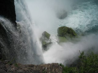

The view you'd have if you jumped over Horseshoe Falls. I'll pass. Although people do, and have gone over it in barrels and stuff. God knows how they survive.


Self-portrait yeah! Phil advised me to try and include some photos taken by me, of me - so while Dad was in the car, I snapped this one. Came out rather well, if I say so myself. Got the waterfall, the boat and the corner of the rainbow. Shame about the nob in front, but what can you do?


We saw this outside our motel. The steering wheel was made of linked chain for chrissake. Awesome.

Also, just to finish, stuff I forgot to include from previous days, aimed at certain people...

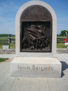
...Well, actually, only Craig. Still. I found this on Antietam battlefield, thought you'd appreciate it. Good Catholic boys, all of 'em.


Well, the plan is tomorrow - get the hell out of Canada. I'll try and get some shots of Toronto, apparently they have some huge arse tower in the city or whatever, so should make good pixellated eye candy. That is of course, unless we meet an untimely end on this pathetic excuse for a freeway. Should be interesting.
Sunday, May 28, 2006

It's a battlefield bonanza!

Well, it's been a few days since I last made a proper update. That's not to say that there hasn't been anything to talk about - a combination of illness, lack of internet, good movies on TV and a slight case of intoxication has combined to keep me from doing the full monty in terms of updating the blog. However, we've stopped somewhat earlier today, and as such, I'm catching up. Where was I? Oh yes. After leaving Manassas and the Air Museum, we spent the next day driving through four battlefields, as mentioned in the previous blog. The first battlefield we saw, Fredericksburg, is the most affected by development out of the four. The original battlefield was fought when the town was a lot smaller, and long, gently sloping ridge existed, stretching from the town up the hills to the Confederate position, where their troops were dug in behind a stone wall. The Union commander, a chap called Burnside, foolishly ordered a frontal assault against this near impenetrable position, resulting in unmitigated slaughter of the Federals, given the strength of the Confederate defences.

Nowadays, houses reach right up to within twenty metres of the wall, with only the wall itself and a small park along the summit of the ridge behind it intact. Whilst it does make it somewhat difficult to visualise how the battle panned out, you can still see some impressive sights.


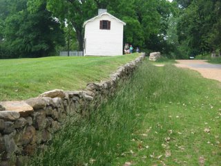
An original section of the stone wall. The Confederates, safely kneeling behind the wall, were able to punish the Federals with relative impunity. Given the ability of a rifle musket to reach out and touch someone at over 300 metres with accuracy, and that the Federals had close to a kilometre of open ground to cross, it's easy to see why the attack was such a catastrophe. In front of the stone wall at Fredericksburg, close to 8000 Federals were casualties, as opposed to scarcely 1000 Rebels.


This graveyard was on the crest of the ridge, and was already present when the battle began. As you can see, it was not spared by Federal cannonballs, which were aimed at Confederate artillery positioned further along the ridge.


The interior wall of a house near the Confederate firing line. The amount of bullet holes to be seen testifies to the ferocity of the fighting that occurred here.


I found this next to the road running behind the wall. Laziest cat ever.

Anyways, after Fredericksburg, we moved on to Chancellorsville, scene of Robert E Lee's greatest ever victory over the Federals. It came at a high price though, losing his best subordinate, the brilliant and ultimately irreplaceable Stonewall Jackson.

Chancellorsville is in a much better condition than Fredericksburg, due to it's distance from urban areas. The battle fought here was a masterpiece of manoeuvre, as Lee and Jackson skillfully redeployed their 60000 troops in such a fashion as to convincingly rout 110000 Federals under Joseph Hooker. Although they were aided in the confusion generated by the thick forests in the area, meaning Hooker was unable to coordinate and bring to bear his full weight of numbers, the same conditions contributed to the circumstances in which Jackson was killed.

The first day of the battle began in late afternoon when Jackson, who had managed to secretly bring 35000 of his troops around to the Union flank, sent his troops forward in a screaming assault on the unsuspecting Union troops in front of him, sending them flying. Although surprise was complete, darkness, and stiffening Union resistance, combined to halt the Confederate advance. Seeking to continue the attack, Jackson personally rode forward with his staff to scout the Union positions. Returning to the Confederate lines by a different route from where they had rode out, the Rebels in the area were unaware that their commanding general had ridden out in front. Mistaking Jackson and his staff for Federal cavalry, they opened fire, blasting Jackson from his horse with bullets in his left arm and right hand. Despite the successful amputation of his left arm, Jackson caught pneumonia, and died 9 days later.

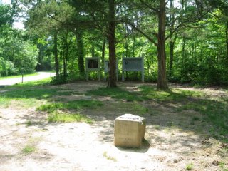
This stone marks a famous location - the site where Lee and Jackson sat on boxes of hardtack and held a firelight conference about how to get at the Federals. It was at the conference that Lee ordered Jackson to swing round and flank the Federals, and it would be the last time they would meet.


This monument marks the location where Jackson was shot and wounded. He fell from his horse and was carried to a field hospital some five miles to the rear (to the right of the photo) where his arm was amputated.


The ruin in front is that of Chancellorsville Inn, where Joseph Hooker had his army headquarters. The house was destroyed during the battle. Behind me was a crossroads (now with traffic lights, a signifcant improvement on 1863), through which Lee rode with his cheering troops after the battle.


Confederate artillery positions on high ground known as Hazel Grove. After Hooker erroneously ordered it abandoned to try and reconsolidate his lines after Jackson's onslaught, the Rebels lost little time in packing it full of artillery to rain shot and shell down on the Union lines, which were based in the most distant clearing. Chancellorsville Inn is actually about 100 metres to the right of the clearing.

After Chancellorsville, we made our way to the Wilderness. Now, I apologise - I don't have any photos there, primarily because at that point, it started to rain very heavily. Unwilling to risk my beloved Ixus to the elements, we contented ourselves with staying in the car and looking. Essentially the first battle fought between Ulysses S Grant and Lee in 1864, the Wilderness was a brutal struggle in very similar terrain to Chancellorsville, which is unsurprising given that the two locations are but three miles apart. Although the battle ended indecisively, Grant managed to get round Lee's flank and head for a small town called Spotsylvania, to try and cut Lee off from Richmond. Lee managed to interpose his army, and 2 weeks of trench warfare followed. By this stage of war, advances in rifles have brought about an increased use of trenches and emplacements. The battlefields of the later Civil War begin to resemble the trenches of World War One.

Some of the worst fighting of the war occurred at Spotsylvania, as Grant tried numerous attempts to pry Lee out his trenches. The most notable instance was at a location known as the Bloody Angle, where the Federals surprised the Confederate division there, and captured close to 3000 men and 30 cannon. In a last ditch effort to stablise his line, Lee hurled a reserve division into combat, and fighting raged from dawn until midnight over the trenchworks. At the Angle, when the fighting had ceased, over 200 bodies were found in a trench not more than 30 metres long.


The Confederate position was to the left of this earthwork, the Union attacked from the right. The trench extends ahead for some 100 metres, where a monument, visible in the distance marks the site of the angle itself.


This was taken at the Angle, and is mute testimony to the carnage that erupted here.


The bloody Angle. The Confederate trenchline follows the patch of unmowed grass. The trenchline here was called the Angle, because it was where Lee's line bent, before stretching away down to the left. Over one thousand men died in the mowed area behind the Confederate trench.

We bivouaced for the night at a town called Culpeper, where I suffered the aforementioned attack of intoxication. Feeling quite hungover, I was dragged into the car by Dad the next day and driven to Harper's Ferry.

Harper's Ferry was a very successful town prior to the war. It was one of two locations where the US Government established armouries, to produce firearms for the United States Army. Sited on the junction of the Potomac and Shenandoah Rivers, it is surrounded on all sides by high cliffs, which makes for fantastic scenery - but not a good place to defend. It would change hands 8 times during the war - it's indefensible location making it easy pickings for both Union and Confederate forces. With the armament producing machines shipped South by the Confederates early in the war, the bridges into down all destroyed during the war, and a series of devastating floods after the war, Harper's Ferry was all but abandoned by the 20th Century. However, it has been given a new lease on life as a historic town - filled with great museums and exhibits. Both Dad and I were surprised at what was to be found here.


A view from a more modern bridge, of a somewhat older bridge. The bridge I'm standing on is a rail bridge - the bridge in front was also a rail bridge, which the Federals blew up in 1862 before they surrendered the town to the Confederates. The Potomac River is in front of me - the Shenandoah enters from the right.


The main drag in Harper's Ferry. Quite a few old buildings are still in place here, along with plenty of older retaining walls, steps etc.

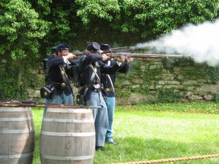
The most interesting part of the day though, at least for me and Dad was an exhibition by re-enactors of firearms from the various eras of warfare, from the Revolution up to the Civil War. While these guys might seem somewhat comical to some of you, they do take it very seriously, and really know their stuff.


A soldier from the war of 1812. This guy was really good - he talked it up nicely, put on a very good show. The musket he has is a muzzle loading smoothbore, accurate only to about 70 metres.


A small platoon known as the 1st Pennsylvania Volunteers, standing at ease. These guys were equipped with muzzle loading rifles, accurate to about 300 metres.


Fire! I've also got some video footage of these guys, which I'll show you at some point I'm sure. (Anyone who knows how to upload videos to blogs, feel free to let me know.)

So, with that, we bid farewell to Harper's Ferry, and this morning made our way to the battlefield at Antietam. Now, Antietam is a spectacular site to visit - it's far from the urban areas that threaten Fredericksburg, Chancellorsville and the like. It's also very easy to picture what happened - the bulk of the fighting occured on open fields, so visibility and a sense of location is easy to achieve. The battle played out in three parts - the first at dawn, in the area known as the Cornfield, the second in the early morning at the Sunken Road, and the last at Burnside's Bridge, in the late morning and early afternoon.


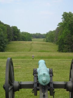
This cornfield doesn't look like much, but it is hallowed ground. By day's end, this field was covered in bodies from both sides. At the time of the battle it was covered in corn, higher than a man. Into this jungle, both Union and Confederate troops charged back and forth, from which many would not emerge. The Union attacked from the far end, directly opposite, and from the right as well. The Confederates counterattacked from where I am standing.


Two angles of the Sunken Road. The Confederates were defending from within the road itself, while Union soldiers attacked from the left in the first photo, and from the right in the second. Bodies were knee deep in the road at the end, as well as in the fields in front of the road. By the end, Confederates were forced to pile their own dead up as cover, before the sheer weight of Union numbers swept them away. The end came when Union soldiers managed to penetrate to where I was standing when I took the second photo, and enfiladed the entire Confederate line, mowing them down where they stood.


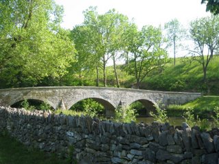
Two shots of Burnside Bridge, so called because of the Union Commander Burnside (the same guy at Fredericksburg.) He managed to completely bungle the attack across the bridge, with his corps of 10000 stalled by about 500 Georgian riflemen on the heights on the far side (the right, in the second photo.) Eventually he managed to get his troops across, but Confederate reserves managed to stop his attack before he could penetrate far into Lee's lines.

It's been a fascinating three days. Tonight we're staying in Hagerstown, in Maryland. Tomorrow I'll be entering Yankee territory for the first time when we cross over into Pennsylvania. With Niagra Falls, Toronto and a fair bit driving to be done, the next few days promise to be just as interesting.

For those of you bored shitless by the military nature of this blog thus far, it's almost at an end. After Gettysburg, the Civil Wargasm that I've been on will draw to a close, and you'll be able to read about more normal pursuits.

Quick update

Just a quick post- I felt a bit sick today, and am labouring under a headache, so, in my infinite laziness I'm just letting everyone know what's happening and going into detail tomorrow night.

Basically, we've been hitting the battlefields hard over the last 2 days. We drove through Fredericksburg, Chancellorsville, Wilderness and Spotsylvania. Four of the largest battles of the Civil War, with only a few miles separating each one. Very interesting to see them today.

We also went to Harper's Ferry, a historical town on the Potomac. Saw some great exhibits, including an excellent live firing demonstration by some re-enactors. Good stuff.

Will post pictures and whatnot tomorrow, if internet is available. We're going to Antietam tomorrow, a battlefield that produced the greatest loss of American lives in a single day - to put it in perspective, five times as many men died at Antietam as the US Army lost on D-Day.

After that we're going to see Niagra Falls, do a loop around Lake Erie and return to Gettysburg to finish up, before we head to New York to return the car and spend a few days there before heading to England.

I'll keep you posted.

Thursday, May 25, 2006

Leaving Washington - but not with any haste

Well, today was our last day in Washington. We didn't go into the city though, merely contenting ourselves with the 'burbs. Our plan today was to see the battlefield of Manassas and then from there visit the Smithsonian Musem at Dulles Airport. The Smithsonian there is basically the same sort of air museum as the one we saw the other day, except it contains all the stuff that's too big to fit into the first one. So as you can probably surmise, it contained some very impressive specimens.

So, to Manassas first, which is a fairly standard battlefield, as they come. One thing that was surprising was the relatively small size of the main area of conflict. At the first battle of Manassas, tens of thousands of troops clashed and died in an area scarcely more than a square kilometre. In part this was because it was the first battle of the war, and as a result the commanders eschewed manoeuvre in favour of brute force, hurling their men into the fight, brigade after brigade. It was in this battle, a relatively unknown Confederate General, Thomas J Jackson, would earn the immortal nickname "Stonewall", for his heroic stand in the face of overwhelming Union odds.

After departing the scene of Jackson's triumph, we headed onto the air museum. I've selected some of the better photos to explain this. Moving right along, we left the air museum and headed for Fredericksburg. This where the lack of haste part comes into it. There are far more cars in Los Angeles than there are in Washington DC. Despite this, the lack of freeways in this place is appalling. We were in pretty much permanent gridlock, on what we would call the equivalent of Pickering St in Brisbane. Cars everywhere. Traffic in this place sucks. If I had to experience what Washington driving commuters experience everyday, I'd harm myself, physically.

Still, at least it gives us an idea of what we're to expect when we attempt to return our car to JFK Airport in New York.

With that said, let's have some photos.


First of all, Stonewall Jackson himself. To accurately depict the oddities of this particular general, they should have had his left hand held up in the air, and his right hand holding a lemon which he would be sucking on. Despite these oddities, he was the Confederacy's most brilliant commander.


A Boeing 707. This is actually quite tiny when compared with a 747, but I would assume technology would improve the size of planes over time. There's alos a host of other planes above and around it which I can't be arsed identifying.


An Air France Concorde, donated to the Smithsonian in 2003. This plane is indescribably beautiful. You have to see it to believe it.


I think this photo angle comes closest to demonstrating the beauty of this aircraft. In the flesh, as it were, it is like the Spitfire. Poetry in motion. Not an angle or panel out of place.


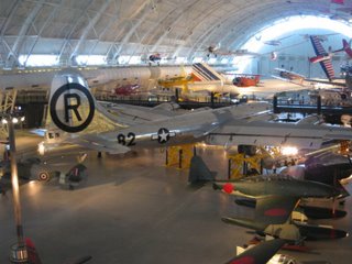
From beauty to brute force. This is the plane that sent the equivalent of 20,000 tons of dynamite nipbound. A B-29 Superfortress, that dropped the first atomic bomb on Hiroshima. The amusing thing was we encountered a group of Japanese looking at this while we were looking at it. Cue the comments from me and Dad "hmmm, it's a bit nippy in here..."

Yes, we are awful people.


Me next to yet another P-47 Thunderbolt. I cannot believe how massive this plane is. It's at least 3 metres behind me in the perspective of the photo and is still towering over me.


Germany's answer to the P-47 - the Focke Wulf 190. A powerful, fast plane with a shattering armament. This came into service in 1941, and remained in service till the end of the war.


The Enterprise! Space Shuttle, that is.


A side view. This particular shuttle was the trainer - it doesn't have the heat resistant tiles, nor does it have rocket engines. It was released from a NASA Jet, and would glide into a landing, providing training for the crew.


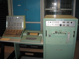
A Univac computer. Looks powerful, no?


Ummm....not really.


Now, I should warn everyone, what follows is nothing short of digital pornography.

It's not quite a Spitfire, but it's close.


Got the kid's eyes closed?


Tom, I'm looking at you here. Alex is too young for this.


Ok, here we go.


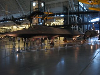
The SR-71 Blackbird. The fastest ever jet propelled aircraft, capable of over 3000 km/h. This particular aircraft is over 30 years old, and flew reconnaissance missions during the Gulf War. Despite being superseded by satellites, they still hold the jet speed record.


Again from the front, this time from the other side.


From dead front on.


And finally, we couldn't end without a moment of redneckery. Seriously - could anyone ever drive a Hummer in Australia without being called a wanker? I think not.